Thank you to those of you who contributed descriptions of your work for the annual highlights reports. We are always interested in new work to highlight, if you publish something yourself, or see something in-print that would be worthy of a highlight.
A new reference publication of interest to Volcano Geodesy
An introduction to several monitoring techniques used in volcano geodesy was published by authors from multiple worldwide volcano observatories who are actively involved in monitoring volcanic unrest. The described methods include EDM, tilt, GPS, InSAR, microgravity and mathematical modelling, and the publication is intended as a reference.
In March 2020, the coronavirus disease 2019 outbreak was declared a pandemic by the World Health Organization and became a global health crisis. Authorities worldwide implemented lockdowns to restrict travel and social exchanges in a global effort to counter the pandemic. In France, and in French overseas departments, the lockdown was effective from 17 March to 11 May 2020. It was in this context that the 2–6 April 2020 eruption of Piton de la Fournaise (La Réunion Island, Indian Ocean) took place. The density and reliability of the OVPF networks, combined with satellite observations, allowed for trustworthy instrument-based monitoring of the eruption and continuity of the OVPF duties in issuing regular updates of volcanic activity in the context of a double crisis: volcanic and health.
Peltier, A., V. Ferrazzini, A. Di Muro, P. Kowalski, N. Villeneuve, N. Richter, O. Chevrel, J. L. Froger, A. Hrysiewicz, M. Gouhier, et al. (2020). Volcano Crisis Management at Piton de la Fournaise (La Réunion) during the COVID-19 Lockdown, Seismol. Res. Lett., 1–15, doi: 10.1785/0220200212.
Dynamics of deformation and satellite thermal infrared at Domuyo volcano, Argentina
The a present a decade-plus analysis that integrates, for the first time, time series of satellite interferometric synthetic aperture radar (InSAR) surface deformation and satellite thermal infrared edifice-scale surface warming at a large silicic system: Domuyo volcano, in Argentina. We find that deformation and warming are highly correlated, and depending on the sign and lag between the time series, either shallow sealing or magma influx could drive Domuyo’s ongoing inflation (~ 0.15 m/year; from an InSAR-derived tabular source, ~ 11 × 8 × 1 km; ~ 6.5 km depth; ~ 0.037 km3/year volume change rate) and warming (0.3–0.4 °C/year). This study shows the potential that combined satellite surface deformation and edifice-scale surface warming time series have on assessing the physical mechanisms of silicic volcanic systems and for constraining deterministic models.
Lundgren, P., T. Girona, M. G. Bato, V. Realmuto, S. Samsonov, C. Cardona, L. Franco, E. Gurrola, and M. Aivazis (2020), The dynamics of large silicic systems from satellite remote sensing observations: the intriguing case of Domuyo volcano, Argentina, Scientific Reports, 10, 11642.
Unsupervised modeling of volcano plumbing with GNSS
We propose a fully unsupervised Bayesian inversion method that uses the point compound dislocation model as a complex source of deformation, to dynamically identify the substructures activated during magma migration. We applied this method at Piton de la Fournaise, using Global Navigation Satellite System data preceding the June 2014 eruption. Obtained source shapes (dikes, prolate ellipsoids, or pipes) show magma migration from 7–8 km depth to the surface, drawing a mechanical “tomography” of the magma pathway. We implemented this method operationally as an extension of the GNSS module in the WebObs system (https://github.com/IPGP/webobs; Beauducel et al., 2020), an integrated web-based system for data monitoring and network management implemented in 15 observatories worldwide. This has been especially useful during the last eruption at Piton de la Fournaise (Peltier et al., 2020, see below).
Beauducel, F., Peltier, A., Villie, A., & Suryanto, W. (2020). Mechanical imaging of a volcano plumbing system from GNSS unsupervised modeling. Geophysical Research Letters, 47, e2020GL089419. https://doi.org/10.1029/2020GL089419
Deformation at Sabancaya Volcano
Sabancaya is the most active volcano of the Ampato-Sabancaya Volcanic Complex (ASVC) in southern Perú and has been erupting since 2016. The analysis of ascending and descending Sentinel-1 orbits (DInSAR) and Global Navigation Satellite System (GNSS) datasets from 2014 to 2019 imaged a radially symmetric inflating area, uplifting at a rate of 35 to 50 mm/yr and centered 5 km north of Sabancaya.
Boixart, G., Cruz, L. F., Miranda Cruz, R., Euillades, P. A., Euillades, L. D., & Battaglia, M. (2020). Source Model for Sabancaya Volcano Constrained by DInSAR and GNSS Surface Deformation Observation. Remote Sensing, 12(11), 1852.
InSAR measurements at Cordon Caulle
Here is a review of InSAR at Cordon Caulle. It is a summary of 17 years of InSAR applied to ground deformation and topography changes observation.
F. Delgado, Rhyolitic volcano dynamics in the Southern Andes: Contributions from 17 years of InSAR observations at Cordón Caulle volcano from 2003 to 2020, Journal of South American Earth Sciences, Volume 106, 2021, 102841, ISSN 0895-9811, https://doi.org/10.1016/j.jsames.2020.102841.
IAVCE is piloting an eVolcano video project to curate and distribute Volcanology videos. Please consider contributing some content! The eVolcano pilot project includes peer-reviewed videos that are 20-30min long scientific lectures covering different fields and subjects in Volcanology, targeting the…
We are pleased to announce the launch of a volcano model verification and validation initiative “Drivers of Volcano Deformation” (DVD), sponsored by CONVERSE/IAVCEI/Modeling Collaboratory for Subduction. DVD Phase 1 consists of several exercises to test commonly used models for ground deformation at volcanoes. As forward and inverse models of volcano deformation increase in complexity, it…
In the 2018, two earth scientists from Slovakia, Pavol Zahorec and Peter Vajda have teamed up with colleagues from Osservatorio Etneo, Istituto Nazionale di Geofisica e Vulcanologia (INGV) in Catania (Sicily), Daniele Carbone, Filippo Greco and Massimo Cantarero to conduct…
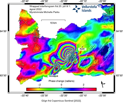
The IMO (Icelandic Met Office) published the interferogram showing new dike intrusion on Reykjanes Peninsula and deformation associated with the M 5.47 earthquake on 31 July 2022. Through this interferogram, it’s possible to observe approximately 16 cm of northwestward displacement…